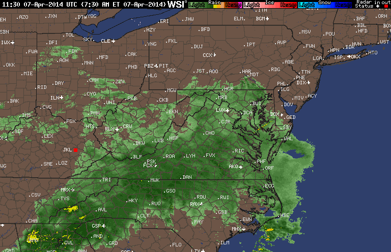
Here's the radar as of 7:30am showing widespread moderate to heavy showers this morning for everyone. This band will slowly drift east, so steady rain will end west to east late this morning into the afternoon. There will continue to be a chance for scattered showers and maybe a few thunderstorms to develop out ahead of the actual cold front which won't pass through until late tonight. Still expecting 0.5-1.0" everywhere with some areas of 1.0-2.0" along and east of the Blue Ridge Mountains.
End Update
---------------------------------------------------------------------------------------------------------------------------------
Sunday (4/6) 5pm:
After a nice weekend, it's looking like Monday will be another washout. An area of low pressure is beginning to take shape across the southern Mississippi Valley this afternoon. It's already producing a nice slug of moisture across some the Gulf states. This low will lift northward along the western side of the Appalachians late tonight through the day tomorrow.

Counter-clockwise flow around the low will help draw in both Gulf and Atlantic moisture leading to pretty decent rain across the entire state. It should start across far south-western Virginia soon after midnight before spreading north-east through the morning hours. There will be widespread 0.5-1.0" amounts across the state with a heavier band dumping as much as 1.5-2.0". The models aren't in agreement with where the heaviest band of rain sets up. The NAM has it setting up across far western Virginia along the spine of the mountains, while the GFS has it further southeast cutting from Danville to Richmond and points south and east. The EURO is a bit in-between the American models which is probably a good bet. It seems that's what the Weather Prediction Center is going with. Below is their 3 day rain total map. This track does usually favor highest amounts right along the eastern slopes of the Blue Ridge mountains where there's some upslope component with easterly/southeasterly winds.

A few showers may hang around late Monday night into Tuesday morning before finally clearing out. The middle part of next week loos cool (50s and 60s) before another nice warmup late next week into the weekend.
No comments:
Post a Comment