Another Severe Thunderstorm Watch has been issued for the area below.
 * PRIMARY THREATS INCLUDE...
     SCATTERED DAMAGING WIND GUSTS TO 70 MPH POSSIBLE
     ISOLATED LARGE HAIL EVENTS TO 1.5 INCHES IN DIAMETER POSSIBLE
     A TORNADO OR TWO POSSIBLE

-----------------
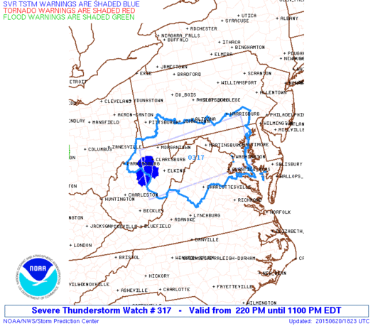
2:25pm Update
Well that was quick. A Severe Thunderstorm Watch has been issued for the area outlined in blue.
* PRIMARY THREATS INCLUDE...
     SCATTERED DAMAGING WIND GUSTS TO 70 MPH POSSIBLE
     ISOLATED LARGE HAIL EVENTS TO 1.5 INCHES IN DIAMETER POSSIBLE
     A TORNADO OR TWO POSSIBLE
--------------------
2pm Update
Earlier forecast looks on track. Morning cloud cover has broken up over allowing CAPE (convective available potential energy--a measure of instability) values to climb into the 1,500-2,000 J/Kg range across the area. A few storm segments are beginning to form out ahead of Bill's circulation over central West Virginia. These will increase in coverage and strengthen through the rest of the afternoon before arriving in the Shenandoah Valley early this evening.
 |
2pm Radar
The Storm Prediction Center has issued a mesoscale discussion highlighting our area may need a Severe Thunderstorm Watch (or possible even a Tornado Watch) heading forward as the risk of damaging wind gusts...and perhaps at least relatively short-lived/weak tornadoes...is expected to increase over the next few hours. Have a way to access any issued warnings this evening.
|
 |
| Mesoscale Discussion Issued by the SPC |
End Update
------------------------------------
Summary:
Last Sunday, an area of convection in the western Caribbean started showing potential to become our second named storm (Bill) of the 2015 Atlantic tropical season. Over the course of 6 days, this area went from a blob of convection to a Texas land-falling tropical storm to what is now a tropical depression about to impact the mid-Atlantic. Although Bill only had maximum sustained winds of 60 mph at landfall (not all that strong by tropical system standards), its unusual characteristic is how well it has maintained its structure and circulation now 4 days later.This is due to its track over a moist, tropical air-mass and very saturated ground. These remnants will bring the potential for flash flooding and severe weather to much of the state later this evening into the overnight. Below are my thoughts for the Shenandoah Valley.
FLASH FLOODING:
 |
| Current radar showing approaching remnants of Bill |
Even with Bill losing its tropical characteristics as it runs into the Appalachians, it certainly won't lose its heavy rain. PWATS (Precipitable Water Values:the measure of the depth of liquid water at the surface that would result after precipitating all of the water vapor in a vertical column over a given location) are sitting between 1.5-2.0". To give an idea of just how moist the atmosphere is, these values should be around 1" this time of year. What's left of Bill will act as a lifting mechanism to squeeze the air-mass out. A saving grace will be Bill's overal increase in forward speed preventing a prolonged event.

Flash Flood Watches Issued for the Entire Shenandoah Valley
- Timing: Scattered light showers around during the morning and early afternoon hours...a line of heavier thunderstorms will move from west to east into the Shenandoah Valley around 5pm...the heaviest rainfall will occur between 5-10pm...eventually tapering to lighter showers which will end early Sunday morning
- Amounts: Generally 1-2" with locally as much as 3" (better shot for these higher amounts across the northern Valley closer to the track of the low)
- Impacts: Rapid rises of creeks and streams...standing water in urban and low-lying areas
SEVERE WEATHER
Although sustained winds won't be an issue here, any thunderstorm during the evening will be capable of becoming strong to severe. There will be plenty of wind shear thanks to upper level support from Bill's remnants. As is often the case in the Shenandoah Valley, the main question will be how much instability we build during daytime heating. More instability = more fuel for thunderstorm strengthening. I do think we'll at least some severe weather in the Valley but the more widespread reports end up east of the Blue Ridge.
 |
| 6z High Resolution NAM Simulated Radar for 8pm |
- Timing: 5-10 pm in the Shenandoah Valley
- Threats: Damaging straight line wind gusts as high as 60-70 mph embedded within segments of storms...lesser potential for small hail and even brief, isolated tornadoes (this threat is higher closer to I-95 where winds will veer (in other words twist) more with height
- Impacts: Scattered power outages, tree damage
Feel free to share any reports/pictures with me on Facebook/Twitter throughout the day. Stay safe and happy early Father's Day!
No comments:
Post a Comment