The Not-So-Hot Month of August
The past few days of slightly above average temperatures have helped bring Harrisonburg's August temperature average to 68.6, dropping it from # 2 to # 3 of the coolest Augusts on record (1946- 68.0; 1927- 67.3). This average will likely climb a bit more with above average temperatures expected today before things dip back below average this weekend into the first part of next week. This mini-heat wave hasn't been quite as impressive as it looked on the models a week ago... pretty much the theme of the past month; long range models try to build an impressive heat dome into the east in the 1-2 week period before backing off as we get closer in time. Below is the 11-15 day temperature departure from average forecast from Thursday's 12z Euro Ensembles...yes right on cue....again showing pretty decent heat over the eastern half of the country to start September. |
| 11-15 Day Departure from Average Temperatures |
Shenandoah Valley Forecast
Friday: If we can get enough sunshine, this will likely end up being the hottest day during our mini-stretch of above average temperatures. Highs should top off in the mid 80s. Another disturbance will pivot through during the early afternoon hours. Radar as of 2am Friday show this disturbance moving a bit faster, so I wouldn't be surprised if some of these made it into the area by late morning. The bulk of this cluster of storms will affect the central and southern Valley down towards portions of southwestern VA. There may some isolated storms that develop behind this first batch during the evening hours...but these should be pretty widespread.
 |
| 500 Millibar Vorticity Showing Disturbance for Friday |
Saturday: The return of the wedge! This will be the 1st day of our transition back into a period of below average temperatures. High pressure will work build its way south out of Canada into New England. Clockwise flow around it will help transition winds from the west to more easterly/northeasterly. This will help usher in cooler, moist air off the Atlantic producing mostly cloudy skies throughout the day along with scattered light showers/drizzle chances, especially right along the mountains where upsloping winds will help wring out some of that moisture. Highs will drop down to at to just slightly below average in the upper 70s/low 80s.
 |
| 10 Meter Wind Barbs Saturday Evening |
 |
| 850 Millibar Relative Humidity Sunday Afternoon |
This cooler pattern will continue into Monday before high pressure fizzles out and we begin another slight warmup towards the middle part of next week. It will be around this time that whatever becomes of Invest 96L (would be named Cristobal if it develops further) will be worth watching in the western Atlantic. Majority of the tropical models seem to want to re-curve this system into the Atlantic, but still too soon to give a definite call on that...especially since the storm has still yet to even get its act together. Keep an eye on it if you have any beach plans along the east coast next week.
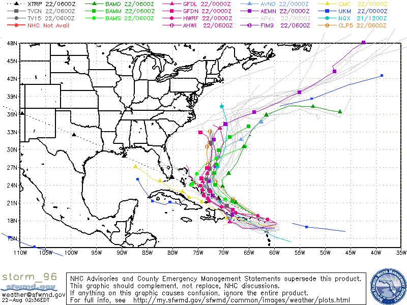 |
| Spaghetti Plots for Invest 96L |
No comments:
Post a Comment