.gif)
This system will move east and allow an area of low pressure to develop in the northern Gulf before tracking up the eastern seaboard. This system will have a pretty massive precipitation shield, so it will begin falling across portions of Virginia early Tuesday morning when the main surface low is still down south of New Orleans. I believe that will will be enough cold, dry air leftover from this latest arctic air mass that precipitation will begin as a wintry mix for the western part of the state. Here's a look at the 12z gfs. Here's the precipitation moving into southwestern areas of the state by Tuesday morning at 7am.

Now here's the surface temperatures for the same time frame. The white line represents the 32 degree freezing line. You can see that there should be just enough cold air for some of these places to at least begin a bit on the wintry side.

There isn't any high pressure area to our north that can keep this cold air in place, so it should quickly retreat, changing everyone over to rain during the day on Tuesday. Some of the more sheltered valleys may hold onto this colder air for a bit longer, but like I said, everyone should eventually go over to rain as southerly flow from the strengthening storm invades the area. Below are a few of the other model depictions of this...all of which are pretty similar.
12z euro for 7am Tuesday

12z canadian for 7am Tuesday

12z nam for 7am Tuesday

The bottom line is that the early morning commute could become a bit hazardous for some Tuesday morning. As we head into the later portion of the day, all areas will change to rain. Some of this may be heavy at times...with widespread 1-2" rainfall amounts. The second shot at wintry precipitation will be as the low passes us and colder air infiltrates the backside under counter clockwise northwesterly flow. I believe this will also be lake enhanced and mainly confined to the western slopes of mountains of West Virginia and western Maryland, but wouldn't be surprised to see a bit of this spill over into the Shenandoah Valley and northern piedmont during the afternoon and evening hours on Wednesday. Here's last nights 00z Euro ensembles depiction for Wednesday afternoon at 1pm.
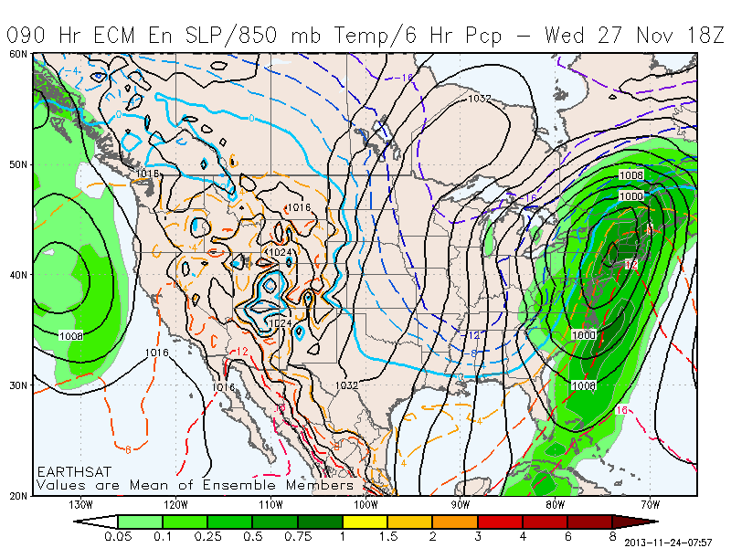
You can see the low is all the way up in New York, but there's wrap around moisture extending all the way down into the mid atlantic. The light blue line is the rain/snow line. This is probably overdone a bit, as backside moisture usually doesn't work out like this with a dry slot quicking taking hold due to sinking winds east of the mountains...but I do think there will be flakes in the area with accumulating snows up in typical upslope favored mountain zones. To get an idea of what this might look like at the surface, here's the Canadian model's depiction for the same time Wednesday at 1pm.

So breaking this up into 2 different chances for wintry weather, here's what I expect.


The most uncertainty I have with this forecast is for the second round of wintry weather Wednesday evening. I'm not sure exactly how much wrap round mositure will be leftover, especially for areas east of the mountains. Overall this shouldn't be a very significant wintry event for Virginia, but some wintry weather none the less.
No comments:
Post a Comment