Sunday, February 15, 2015

2nd Call for Monday-Tuesday Storm

(Tuesday 10am update)
Here's a at some final totals across the state:


Looking back at my forecast...parts of Southside VA didn't quite reach the 4-8" mark mainly due to an earlier transition to sleet. Also, a few central and northern Shenandoah Valley locations were shy of the mark thanks to all the dry air in place at onset (dew points in the negative teens for a lot of places!!)

End Update
-----------------

(Monday 9:45pm update)

Well that was fun...thanks for all the reports and pictures today. Steadier snow across western Virginia will begin tapering off to flurries and light snow showers over the next few hours. We still have a good ways to go across southside, central, and eastern portions of the state where snow (mixing with sleet in some locations) will continue through early morning. I'll have a look back at final totals once everything is all said and done tomorrow.

Looking ahead, temperatures look quite cold the rest of the week. Another arctic front will bring another round of scattered snow squalls and howling winds across the area Wednesday (very similar to what we saw over the weekend). Behind this front, expect an even more significant arctic blast with highs well below average Thursday and Friday. Thanks to help from snow cover, the Shenandoah Valley has the potential to see more low single digit (if not sub-zero) lows Wednesday, Thursday, and Friday nights. It's safe to say snow isn't going anywhere anytime soon. Already keeping an eye on another storm threat next weekend

End Update
---------------
(Monday 4:45pm update)
4:45 pm update: a mesoscale discussion has been issued for areas of heavy snow developing across the circled area through the rest of the evening. 1-2" per hour will be possible under heavier bands.
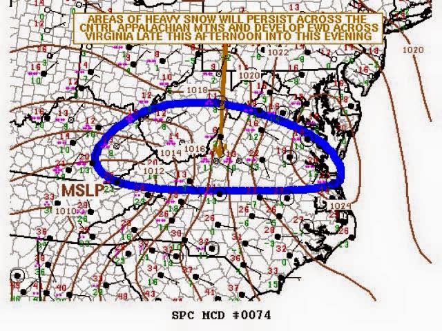
MD for heavy snow issued by the WPC

 Snow shield is still having a bit of a time overcoming dry air in place over northern parts of the state...this was expected and will continue to fill in as moisture increases. 4-8" Shenandoah Valley wide still look like a solid bet... With isolated higher totals across southern portions and higher elevations.
4:45pm radar
End Update
--------------

(Monday 9:30am update)
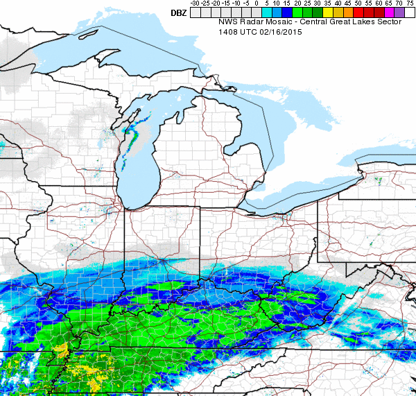
Phew..electricity is finally back on....no huge changes regarding the storm and won't be making any final changes to yesterday's 2nd call map. A leading band stretched across parts of southwest and southside VA is producing a few flurries and snow showers for some, but not all of this is reaching the ground. I'm still liking onset between 1-4pm across most of the Shenandoah Valley but wouldn't be surprised to see a few flakes make it to the ground an hour or two earlier for southern Valley locations. Snow will start sticking immediately so try to be out off the roads.

Image: Radar 9:08am


End Update
------------------------
(Monday 4am update)
No power here in blacksburg means my morning update will come late....will when I can!
End update
-------
(7pm update)
After going over the afternoon guidance, went ahead and upped areas discussed earlier.  I still have concerns regarding the effects of dry air east of the mountains but can't ignore model guidance consistency at this point.  The timing mentioned below still looks to be on track.  One last final call will be out by 8 am Monday morning.

A few other important points (mentioned on Facebook Page already):

  • Due to this recent arctic blast, surface temperatures (including roadways) are well below freezing. When snow starts falling, it's going to start sticking right away...certainly not something you'll want to be out driving in. I hope schools/businesses take this into account while making decisions for tomorrow.
  • After this storm departs, temperatures will struggle to make it above freezing across a lot of the area through the rest of the week. In fact, another arctic blast similar (actually likely even colder!!) to the one we're seeing today will arrive Wednesday and last through the end of the week. Put tomorrow's snow and the next blast of arctic cold together and looks like school kids will be pretty lucky this week.

Second Call Map for Monday-Tuesday
END UPDATE
-------------------

(Posted 1pm)

Overview:
Low pressure will form along the Gulf Coast early Monday morning before tracking northeast through the Carolinas.  Precipitation spreading north of this system will override very cold, arctic air currently in place over the mid Atlantic leading to a period of wintry weather.  Recent trends suggest a more northerly tracking low leading to a few things:  1) increased sleet and freezing rain potential along and south of the Virginia/North Carolina border and 2) increased snowfall totals across the northern 1/3 of the state including the entire Shenandoah Valley and Fredericksburg/DC areas.  It looks like the heaviest snow will fall across the higher elevations of southern West VA and southwest VA where upslope enhancement comes into play.  Models suggest I may be under-doing snow amounts across much of central Virginia.  My reasoning for that is the fact this will be a relatively quick hitting system that'll have to overcome quite a bit of dry air initially (dew points likely in the single digits or lower)...will have an updated final call with any necessary changes out later this evening or tomorrow morning.

Shenandoah Valley General Thoughts:

Timing: A lot of above-mentioned dry air in place will cause much of the initial precipitation to fall as virga, drying up before it reaches the ground.  My best guess at onset is between 1 and 4 pm....starting southwest to northeast.  Snow will become steadier through the evening hours with the heaviest between 7pm Monday and 5am Tuesday.  The storm will taper off west to east during the mid morning hours.  

Amounts: I do expect this to remain all snow here.  A general 3-6" is a good bet across the southern and central Valley with 1-3" further north.  I do think there will be isolated higher amounts (won't be surprised to see a 8-10" report or two, especially in surrounding mountain locations).

Uncertainties: Thanks to what looks to be a pretty sharp northern QPF cutoff, will have to adjust the 3-6" line north  or south based on how far north the low tracks.  In other words, the 1-3" over the northern Valley may very well need to be upped to 3-6" in my final call. 


First Call Map for Monday-Tuesday

No comments:

Post a Comment