12/8 4am
Synoptic Setup:
We have a strong area of high pressure (1044+ mb) building over New England. You can already see this extending down the eastern side of the Appalachians (1032 mb line down to the VA/NC border---pretty impressive)...yet another CAD (cold air damming) event that will lead to a light wintry mix event across the area.
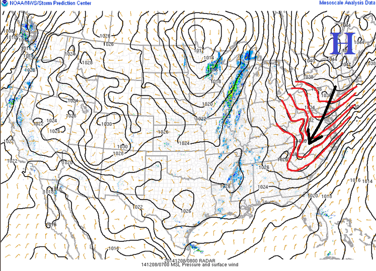
A coastal low is expected to form off the Carolinas before tracking north up the coast. We should see an area of precipitation form right along the eastern facing slopes of the Blue Ridge (thanks to some easterly upslope enhancement) in North Carolina before having that expand and move north into our area this evening. We'll be pretty dry initially (dew points in mid to upper 20s) so we can count on some evaporational cooling at onset to produce areas of mixed precipitation...even without a strong source of cold air.
A few things to keep in mind:
- not much precipitation for our area with this...just a glancing blow
- marginal cold air...so elevation will once again be key
- wrap around light rain/snow showers possible Tuesday into early Wednesday as storm departs and a piece of northern stream energy comes into the mix....some light to moderate accumulations in the mountains

12/8 230pm update
A winter weather advisory has been issued for the central and northern Shenandoah Valley....
*ACCUMULATIONS...A TRACE TO A COUPLE HUNDREDTHS OF AN INCH OF ICE. SNOWFALL AROUND AN INCH.

12/8 4:10pm update
Winter weather advisories have been extended south to now include the entire Shenandoah Valley and parts of the New River and Roanoke Valleys.
* ACCUMULATIONS...SNOW AND SLEET ACCUMULATION OF UP TO 1
INCH...HIGHER ELEVATIONS BETWEEN AMHERST AND BATH COUNTIES MAY
HAVE 1 TO 2 INCHES...ISOLATED TRACE AMOUNTS OF ICE.

No comments:
Post a Comment