Storm Chase Trip
Well I'm back from my 8 day, nearly 5,000 mile adventure in the Great Plains chasing storms with StormCruzzer. Although we didn't see the picturesque tornadic supercell we were after, the week provided several great storms (one with a confirmed tornado touchdown that we witnessed touch down for 20-30 seconds).
 |
| Brief tornado we saw in SE Wyoming (5/20) |
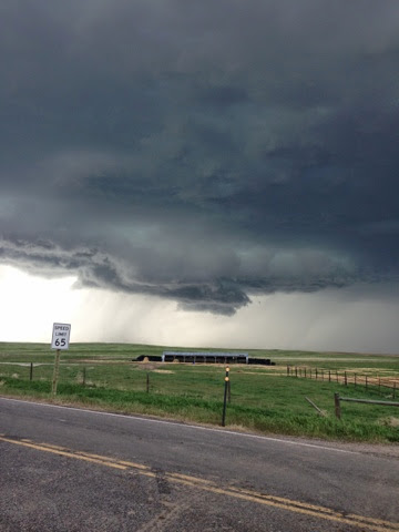 |
| Low hanging wall cloud in eastern Wyoming |
 |
| StormCruzzer |
Now back in Virginia, I plan on returning to the blog routine. The focus will be on Shenandoah Valley weather with the exception of when more significant events occur across other parts of the state.
Nice Weekend Ahead
Moist easterly winds off the Atlantic will start Friday off with a low cloud deck and a few light rain showers/drizzle. A backdoor cold front will work its way into the area by afternoon allowing winds to switch to more out of the north and bring in much drier air. High temperatures Friday will depend on how much sunshine can break out once the clouds start to break in the afternoon. It looks like there should be enough to push temperatures into the lower 70s.
 |
| Early day drizzle/light showers (via psu-ewall) |
High pressure will work in behind the front and clear things out completely for the weekend. Skies will be mostly sunny both Saturday and Sunday with high temperatures climbing into the mid 70s. It's definitely looking like perfect graduation party weather! The chance for showers and storms will return with an approaching cold front by the early part of next week. In other news, is it winter yet?
No comments:
Post a Comment