The South Trend is On
I mentioned yesterday that the timing of the cold front swinging through the area was going to be huge in determining who saw how much snow. The early Saturday morning model runs have really sped up the surge of cold air coming into the region Monday morning. Below shows how drastic this change has been. Both of the images are the 2 meter temperatures for Monday morning at 7am. On the left is the early 6z run from Friday morning of the gfs, while the right is the early Saturday morning 00z gfs run.
You can see the 32 degree surface temperature line is a good 100 miles further south on the latest run than what we were seeing earlier on Friday. It looks like the models are picking up that the arctic air mass moving in behind the front is going to be stronger. With a more vigorous high pressure pushing into the upper midwest, the front is forces to sink further south quicker. To varying degrees, most other model guidance (euro, euro ensemble mean, gfs ensemble mean, canadian, ukmet) are all also on board with this. The two exceptions have been the NAM and SREF, but we're still outside their good ranges (inside 48 hours). Without focusing on exact numbers (I do think these are overdone), check out the snowfall maps below from the Euro 2 days ago on the left vs the current Euro run on the right. The axis of heaviest snow has shifted a good 150-200 miles because of how south the cold front gets.
The keys here will be:
1) how quickly the cold front pushes through
2) how much moisture is leftover behind the front
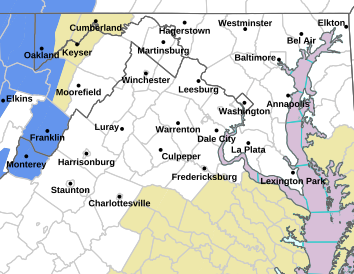
The 00z runs have led the National Weather Service in Sterling to issue winter storm watches for its entire county warning area for 5+ inches of snow.
Below is my first guess map I put out Friday evening. I'm not going to update this just yet. I want to see if the Saturday mid-day 12z runs give any more credence to last night's shift. So just as a heads up, there's a good chance my totals will need to upped and shifted further south when I put out my next map Saturday evening.


No comments:
Post a Comment