Here Comes Spring
It's about that time of year when we are moving further and further away from winter as spring quickly approaches. Days are getting longer as the angle of the sun gets higher. Cold high pressure systems are now moderating more and more as the southeast ridge starts extend its warmth farther north and west.
We have had significant winter storms in Virginia all the way through March and into April (especially for western areas) so saying winter is over for good would be a gamble. It just takes a lot more factors coming together just right for it to happen, but it certainly can.
As spring nears, the major weather event in our area gradually transitions from snow to severe weather. Summer usually becomes a bit of a downtime for the blog. In the past, I've updated the Facebook page occasionally for tropical storms and some of the larger severe weather events across the area. As much as I'd love to forecast snow all-year-around, my goal is to keep it running for marginally severe events, heat-waves, flooding, 80 degrees and sunny, etc.
Severe Weather Wednesday-Basic Discussion
A strong low pressure system is going to track from southern Illinois tonight to Pittsburgh to just south of New York City by tomorrow evening. This track will put us in the warm sector of the storm initially with warm winds out of the south during the day tomorrow. The storm's trailing cold front will pass through during the late afternoon-evening hours bringing a line of showers and thunderstorms.
 |
| 2pm Temperatures -18z nam via AccuPro |
The cold front will likely pack a thin squall line of thunderstorms, some of which may be severe with damaging wind gusts being the greatest threat. Below is a rough timeline of the line:
 |
| 4pm radar-18z nam via AccuPro |
 |
| 6pm radar- 18z nam via AccuPro |
 |
| 8pm radar- 18z nam via AccuPro |
Here's the 12z NMM (left) and ARW (right), both for 7pm Wednesday evening showing very similar squall line formation as the 18z nam above.
 |
| 7pm radar-12z nmm (left) arw(right) via PSU E-Wall |
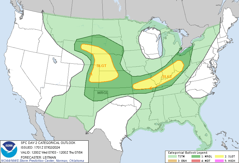
Here's the current convective outlook from the Storm Prediction Center with a slight risk of severe storms covering well over 3/4 of the state. Within this zone, the area in Virginia I currently see with the best shot would be just east of the mountains; a triangle from Charlottesville to Richmond to DC. This is where the the best dynamics will team up with the better instability. Once again, damaging wind gusts look to be the biggest threat. Even outside this area, expect some gusty showers with some thunder and lightning possible. Behind the front, much colder air will be ushered in Wednesday night into Thursday. There will likely be a brief period of upslope snow showers in the mountains of West Virginia/far western Virginia. I wouldn't be surprised to see a few flurries bleed into the western valleys. Stay up to date with your local National Weather Service for any watches/warnings that may be issued tomorrow.
Severe Weather Wednesday- More In-depth Analysis
One of the bigger questions concerning severe weather tomorrow will be how much instability we build by the time the line passes through. Cape values look to be generally in the 300-500 range. This isn't very unstable by any means but it usually doesn't take much with strong dynamics of early Spring cold-frontal systems. The warm front will setup just north of our area, enhancing directional shear aloft.
 |
| Cape-2pm (left) 8pm (right)-18z nam via AccuPro |
Of course any additional instability we can add with breaks in cloud cover during the early afternoon would certainly aid severe storm development. Below is the 18z nam showing that areas south of the warm front draped across the Mason-Dixon may be able to squeeze out some sunshine prior to the approaching line. How much sun breaks out will have to be watched.


No comments:
Post a Comment