
It's crazy how much this storm has evolved over the past 24 hours. Over the early part of the weekend, it appeared that this would just be yet another clipper (although the Canadian model from Saturday showed it may become something more before it too backed off). The morning 09z SREF (short range ensemble forecasting) model from Sunday morning was really the first to hop on the idea that this clipper would round the base of the trough and develop a surface low pressure somewhere across North Carolina. The rest of the afternoon 12z models quickly hopped on board after that. Since then, there has been a few gradual trends in most all of the models that can't be ignored. First off, the amount of precipitation (qpf) has increased, mainly due to the models picking up on the development of the surface low. Secondly, the storm appears that it will track a bit farther north, which would also take the best moisture and higher snow totals farther north as well. That creates a tough forecast for the southern portion of Virginia. With the low tracking farther north, there will be an area across the southern part of the state that gets dry slotted. This is where the biggest bust potential (high or low) exists with my forecast.
Here's the 12z NAM showing total precipitation over the next 48 hours. You can clearly see where dry air tries to work its way into Roanoke, Lynchburg, and Danville.

12z GFS...same story

12z rgem... probably the most pronounced with dry air getting all the way up into Charlottesville and Richmond.

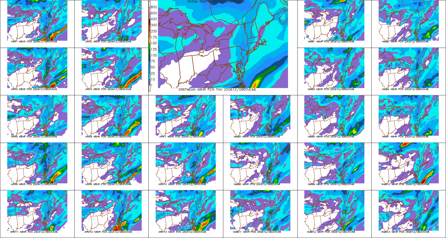
And finally the 09z sref model runs from today... 21 members plus the mean on the bottom right.
With that being said, it looks like the northern half of the state (Staunton to Charlottesville to just north of Richmond) is pretty locked into seeing .25-.50" of precipitation fall as snow. Anywhere from Roanoke to Lynchburg to south of Richmond, the forecast is going to be a bit more tricky. The precipitation gradient is going to be pretty drastic. This will all depend on the track of the low. The further north it tracks, the farther north the dry slot will get. I believe this system is done trending north, but now the question will be if it nudges back a bit south over the next 12-24 hours. I've seen it happen countless times.
Another important thing to remember with this storm is that ratios will not be your standard 10 inches of snow for every 1 inch of precipitation. Below is the 12z gfs temperatures for early evening Tuesday when the bulk of the snow is falling for most areas. The entire layer will be extremely cold, helping to create some higher ratio snows. The 10:1 will become more like 15:1 or even 20:1 at times for higher elevations.
Once this system goes through, things are going to be very cold Tuesday night through the end of the week. Snow pack will help lock in colder temperatures. Wednesday, most areas will struggle to get out of the 20s for highs (teens for the mountains). Lows will once again drop into the teens/single digits for the remainder of the week. There could be another clipper system that moves through during the later portion of the week.
No comments:
Post a Comment