The overnight and afternoon model runs are coming into much better agreement in regards to the Thursday/Friday snowstorm for the mid-atlantic and northeast. Two systems (one dropping out of the plains and one coming out of the Gulf) will combine to form a strong area of low pressure off the eastern seaboard. The problem is that these two systems will remain separated until they're departing our area. This will keep precipitation light (dry for many) until this intensification occurs. The biggest question mark has been exactly when this will happen.
Taking a look at the latest SREF (short range ensemble forecasting) images, you can see that the majority of them have filled in the mid atlantic dry slot to some degree. A few that combine the northern and southern stresm energy too late, leaving the dry slot across our area. With that being said, the bottom right image is the mean which is showing .25"+ of qpf across the entire state. This is a big change from yesterday's sref members.
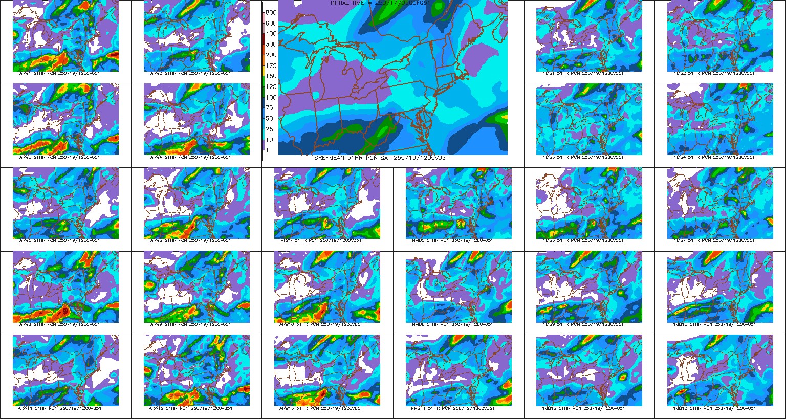
The snowfall SREF mean accumulations for a few stations. Keep in mind that this is the average of all the members. There's usually some members that are 2x higher and some 2x lower than the mean:
KROA (roanoke)- dusting
KSHD (Shenandoah Regional Airport) - 1.13"
KLYH (Lynchburg)- dusting
KRIC (Richmond) - .54"
KCHO (Charlottesville) - .75"
KOKV (Winchester) - 3.54"
KDCA (Washington DC) - 3.19"
KEZF (Fredericksburg) - 1.78"
KPHF (Newport News) - .28"
KLNP (Wise) - 2.46"
Here's some of the snowfall maps from a few short range models. Starting to see pretty decent agreement:
12z high resolution nam
12z RGEM (high resolution canadian)
The agreement between the 09z sref, 12z high-res nam, and 12z rgem is telling me that this storm should get going off the coast soon enough to bring minor to moderate snows to some parts of VA. The highest totals will be in the mountains of far south-west Virginia, and then again across northern VA, especially as you get closer to DC. This will be where a wrap around band may put down snow at a pretty good clip as the storm bombs off the coast prior to departing up the coast. I think the 12z wrf (shown below) has a pretty decent handle on the evolution of this system.
With all that being said, here's my 2nd guess map. Final Call will be issued tomorrow evening


No comments:
Post a Comment