For snow lovers, this winter has been awful. The pattern has been awful. The spring-like weather has been awful. Overall, it's just been awful. But finally, February is going to bring about a change. Historically, February is the snowiest month for Virginia to begin with. It looks like it will keep that title this year. Below is what I posted yesterday which sparked all my excitement.

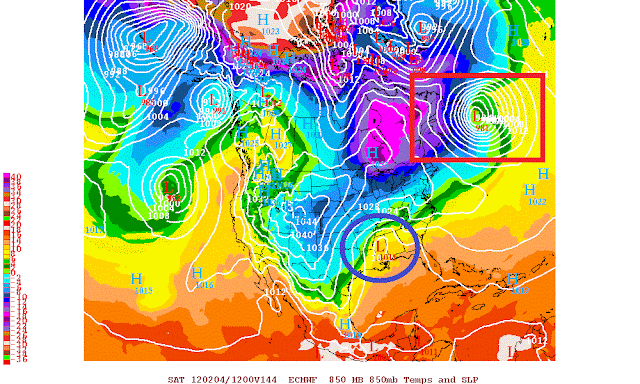
As you can see, a pretty positive PNA is expected to develop towards the end of next week. This in turn will allow a trough to dig into the east coast. Unlike earlier this winter, this trough is not going to be quickly shot east off the coast with a strong crashing storm into the Pacific Coast. Instead, it's going to stay in place for at least 5-7 days. Does this equal a MECS (major east coast storm)? No, but it's definitely a good start. Both the euro and the gfs both show multiple storms tracking across the country beginning late next week. I won't go into the exact timeframes right now because there are still quite a bit of discrepancies, but we're looking at sometime mid to late next week. The first low is basically a non event for VA. Yes there could be a storm, but with no blocking in eastern Canada or negative NAO, I'm not expecting anything major. Anything that does form would most likely be in the form of rain anyways, since cold air will not yet be in place. It is where the gfs and the euro are taking this first low which sets the stage for the potential for a major east coast storm later in the weekend. The picture below is the 12z euro solution for the first storm at 96 Hours. Notice the area I boxed in at red. There is no significant blocking (no 5050 low) that is crucial for a snowstorm to develop. In turn, you can see how VA is way too warm and no coastal storm develops.

But watch where this first storm ends up as it moves northeast into Canada. It ends up turning into the 5050 blocking low that we need. I have to point out that the low this run does not end up in an "ideal" location(we would like it a bit farther south), but still decent enough to cause the NAO to drop to at least neutral if not slightly negative and keep that high pressure just north of the Great Lakes in place.
This is just as the Euro and GFS models are predicting another low to form somewhere around the deep south before tracking northeast into the area. Notice how the cold air is now established in Virginia before the next system arrives. Now I know this is still a week away, but like I said, all the ingredients are on the table! The same pattern with the strong ridge in the west and deep trough in the east even looks to continue through the better part of the beginning of February. There are signs of even a stronger storm with a better setup coming the following weekend, but I'm going to focus on this initial threat first. I'm going to leave you with the most recent model solutions from both the Euro and the gfs. They are actually quite similar right now when it comes to the second storm. They both depict Miller B type events, which are low pressures that redevelop near the shoreline before moving up the coast.
Here is the 12z Euro:
And the 18z gfs:
So, although the setup is now there, it is still way too soon to be forecasting exact snow totals. The path of the low, the intensity of the low, the position of the 50/50, etc are all going to have to be decided this upcoming week before we can start forecasting who really will see snow and how much. I decided not to put any model-predicted snowfall amount maps on here simply because it's too far away. We'll keep you updated throughout the week as the event nears. -HV


No comments:
Post a Comment